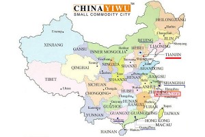
Yiwu City is located in the central part of Zhejiang Province, with an east longitude of 119°49′~120°17′ and a north latitude of 29°02′13′′~29°33′40′′. It is adjacent to Dongyang in the east, Yongkang and Wuyi in the south, Jinhua and Lanxi in the west, and Zhuji and Pujiang in the north. From the county to the town of Dongyang County, 18 kilometers to Yongyang County, 78 kilometers to Yongkang County, 71 kilometers to Wuyi County, 55 kilometers to Jinhua City, 35 kilometers to Pujiang County, 55 kilometers to Zhuji County, and 158 kilometers to Hangzhou, the provincial capital. The total area is 1105.46 square kilometers. [5]
topography
Yiwu City is surrounded by mountains on the east, south and north. There are medium and low mountains, hills , hills and plains in the territory . The soil types are diverse and the light and heat resources are abundant [2] . It is a typical hilly county with various types of landform structure. The northeastern mountainous areas include the entire Dongtang Township and the middle and low mountain areas of Yulin, Qiaoxi and Huaxi. The area of the middle and low mountains and hills accounted for 62.7% and 33.3% of the total area respectively. The main peaks were 900 meters above sea level. The steep slopes above 25 degrees and the slopes of 15~25 degrees accounted for 89.78% of the total area of the area. [6]
Climatic characteristics
Yiwu has a subtropical monsoon climate, mild and humid, with four distinct seasons. The annual average temperature is around 17 °C. The average temperature is the highest in July, 29.3 °C, and the lowest in January, 4.2 °C. The annual average frost-free period is about 243 days, and the annual average precipitation is between 1100 and 1600 mm. [2] [7]


